
1616: “Robins Island"
Interesting Things with JC #1616: "Robins Island" – A strip of sand appears and people start crossing. The island is used but never fully taken. Time moves across it without changing it. By the time you can see it… you may already be somewhere that does not let you leave.
Curriculum - Episode Anchor
Episode Title: Robins Island
Episode Number: 1616
Host: JC
Audience: Grades 9–12, Introductory College, Homeschool, Lifelong Learners
Subject Area: History / Environmental Studies
Lesson Overview
Objectives:
Analyze how geography influenced land use on Robins Island from 1616 to the present
Explain shifts in ownership and land management over time
Evaluate how isolation impacted development decisions
Assess modern conservation practices in relation to historical land use
Essential Question: How does geography influence whether land is developed, used, or preserved?
Success Criteria:Students can trace timeline changes in land use
Students can explain why Robins Island remained undeveloped
Students can connect historical use to modern conservation
Student Relevance Statement: Understanding land use decisions helps students interpret modern development, conservation, and environmental responsibility.
Real-World Connection: Coastal land today faces similar pressures between development and conservation.
Workforce Reality: Careers in environmental management, land planning, and conservation require balancing economic and ecological priorities.
Key Vocabulary
Peconic Bay (puh-KON-ik): A body of water between the North and South Forks of Long Island
Indigenous (in-DIJ-uh-nuhs): Native populations originally inhabiting a region
Land grant (land grant): Legal allocation of land by authority
Grazing (GRAY-zing): Feeding livestock on natural vegetation
Revolution (rev-uh-LOO-shun): A major political upheaval, here referring to the American Revolution
Restoration (res-tuh-RAY-shun): Process of returning land to a natural or original state
Wetlands (WET-lands): Areas saturated with water supporting specific ecosystems
Salinity (suh-LIN-i-tee): Salt concentration in water
Migration (my-GRAY-shun): Seasonal movement of animals
Narrative Core
Open: A narrow strip of sand appears at low tide, reaching toward an island that has remained largely unchanged for centuries.
Info: Robins Island, located in Peconic Bay, was observed and mapped by European traders as early as 1616.
Details: By 1636, English control transformed the island into a working landscape for grazing and timber. During the American Revolution, it became part of a network of hidden movement and observation. Afterward, it remained privately used but undeveloped due to its isolation. In 1993, ownership shifted toward conservation rather than development, restoring ecosystems and protecting wildlife.
Reflection: The same qualities that made the island useful—its isolation and location—also prevented large-scale development, preserving its natural state.
Closing: These are interesting things, with JC.
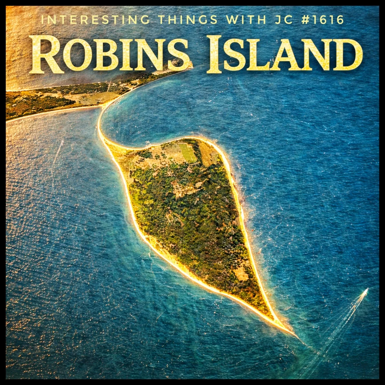
Impressionist Aerial view of Robins Island in blue coastal waters, connected to the mainland by a narrow sandbar at low tide, with green vegetation covering most of the island and a small boat visible nearby. Large text reads “Robins Island” and “Interesting Things with JC #1616.”
Transcript
Interesting Things with JC: "1616: Robins Island"
At low tide, a narrow strip of sand reaches out from the North Fork toward a small island in the middle of the Peconic.
That island is Robins Island, about 435 acres, or 176 hectares, in the Great Peconic Bay, and in 1616 it was already being watched, measured, and approached by European traders moving along the coast. Not settled yet, but noted. Mapped. Positioned.
Within twenty years, that changes. In 1636, under a land grant tied to King Charles I, the island moves into English control as part of expansion across Long Island. Land used by Indigenous communities becomes assigned property, and Robins Island turns into a working place.
Livestock grazing. Sheep and cattle kept apart from the mainland but close enough to manage. Timber taken when needed. Its isolation made it useful. Its position in the bay made it reachable. It sat near trade routes without sitting inside them.
Then the war moves through.
During the American Revolution, these waters carry intelligence. Caleb Brewster moves through this region as part of the Culper Spy Ring under George Washington. Secret crossings. Concealment. Observation without drawing attention. Robins Island sits inside that geography, not as a battlefield, but as a place you move through when being seen is the risk.
After the war, it returns to private use. Farming. Grazing. Limited structures. Ownership changes, but the use holds. No town forms. No port develops. Access stays difficult enough that large-scale building never takes hold.
While the rest of Long Island fills in with roads and houses, this island does not follow. Its soil remains largely undisturbed. Dunes hold. Shoreline keeps its shape. The same conditions that made it useful early on keep it from being absorbed later.
In 1993, Louis Bacon buys the island for about 11 million dollars.
He is not a local farmer and not a developer. He is a hedge fund founder, part of the modern financial world where land like this is usually turned into something else, subdivided, built out, consumed.
And that’s where this turns.
Because instead of building on it, he locks it down.
Not toward development. Toward restoration.
Native oak is replanted. Deer populations are reduced so forests can recover. Wetlands and shoreline are protected. Species that struggle elsewhere, including migratory birds and the Eastern mud turtle, continue here.
The island is still private. There is a residence, controlled access, managed land use. Protection over expansion.
Four hundred years of ownership, war, farming, and recovery, and it remains what it was in 1616, a piece of land defined by use, not by what was built on it.
These are interesting things, with JC.
Student Worksheet
Comprehension Questions:
Where is Robins Island located?
What was its primary use after English control began?
Why was the island useful during the American Revolution?
What prevented large-scale development?
What changes occurred after 1993?
Analysis Questions:
How did geography influence the island’s use over time?
Why might isolation both help and limit development?
Compare early land use with modern conservation practices.
Reflection Prompt:
Should all undeveloped land be preserved? Why or why not?
Difficulty Scaling:
Basic: Identify key facts
Intermediate: Explain cause and effect
Advanced: Evaluate long-term land use decisions
Student Output: Written responses (short answer + paragraph)
Academic Integrity Guidance: Use only lesson content; cite reasoning clearly; no external copying
Teacher Guide
Quick Start: Play audio → discuss → worksheet → review
Pacing Guide:
5 min: Bell ringer
8 min: Audio
12 min: Discussion
15 min: Worksheet
5 min: Review
Bell Ringer: What makes land valuable—location, resources, or access?
Audio Guidance: Students listen for changes in land use over time
Audio Fallback: Teacher reads transcript aloud
Time on Task: 45 minutes
Materials: Transcript, worksheet, map of Long Island
Vocabulary Strategy: Pre-teach key terms before audio
Misconceptions:
All land gets developed
Isolation always limits usefulness
Discussion Prompts:
Why didn’t Robins Island become a town?
What makes conservation decisions difficult?
Formative Checkpoints:
Timeline accuracy
Vocabulary usage
Differentiation:
Provide guided notes for support
Extension writing for advanced learners
Assessment Differentiation:
Oral responses allowed
Written paragraph for advanced
Time Flexibility: Expand discussion or assign worksheet as homework
Substitute Readiness: Use transcript + worksheet independently
Engagement Strategy: Map visualization of island location
Extensions: Research other preserved islands
Cross-Curricular Connections:
Science: ecosystems
Economics: land value
SEL Connection: Responsibility for shared environments
Skill Value Emphasis: Critical thinking, evidence-based reasoning
Answer Key:
Comprehension: (1) Peconic Bay (2) Grazing/timber (3) Concealment/movement (4) Isolation/access (5) Conservation/restoration
Analysis: Geography shaped use; isolation limited development; conservation reversed impact
Quiz
What body of water surrounds Robins Island?
A. Atlantic Ocean
B. Peconic Bay
C. Long Island Sound
D. Hudson RiverWhat was a primary use of the island after 1636?
A. Industrial factory
B. Military base
C. Livestock grazing
D. Urban housingWhy was the island useful during the Revolution?
A. Large population
B. Hidden location
C. Strong defenses
D. Major portWhat prevented development?
A. Lack of ownership
B. Poor soil only
C. Isolation and access
D. Government lawsWhat happened after 1993?
A. Urban expansion
B. Industrial use
C. Conservation efforts
D. Abandonment
Assessment
Open-Ended Questions:
Explain how Robins Island’s geography influenced its historical uses.
Evaluate the decision to preserve rather than develop the island.
Rubric (3–2–1):
3: Clear explanation with evidence and reasoning
2: Partial explanation with limited support
1: Minimal or unclear response
Exit Ticket: One reason the island remained undeveloped and one impact of conservation
Standards Alignment
NGSS HS-ESS3-3: Analyze human impact on natural systems through land use changes
CCSS RH.9-10.2: Determine central ideas of historical texts
C3 D2.Geo.4.9-12: Analyze relationships between human populations and environments
ISTE 3: Knowledge construction through real-world issue analysis
Career Readiness: Evaluate environmental decision-making in land management
Homeschool/Lifelong Learning: Apply historical reasoning to modern land use
Show Notes
This lesson explores how geography, history, and decision-making intersect on Robins Island. Students examine how land can remain unchanged over centuries due to access, use, and intentional preservation, offering insight into modern environmental choices.
References
Peconic Estuary Partnership. (2023). About the Peconic Estuary. https://www.peconicestuary.org/stateoftheestuary/
New York State Office of Parks. https://parks.ny.gov/visit/regions/long-island
Molloy University. Long Island History. https://www.molloy.edu/about/community-outreach/history-of-long-island/
Robins Island - Grokipedia. https://grokipedia.com/page/Robins_Island#:~:text=Robins%20Island%20is%20a%20435,current%20value%20exceeding%20$500%20million