
1543: "John Deere and the Problem of Plowing Blind"
Interesting Things with JC #1543: "John Deere and the Problem of Plowing Blind" – A whiteout turned the highway invisible. But Moe Mohamed’s plow kept moving, guided by a system built for cornfields, not roads.
Curriculum - Episode Anchor
Episode Title: John Deere and the Problem of Plowing Blind
Episode Number: #1543
Host: JC
Audience: Grades 9–12, college intro, homeschool, lifelong learners
Subject Area: Technology and Engineering, Geography, Earth Science, Transportation Systems, Digital Systems Integration
Lesson Overview
Students will:
Define precision guidance systems and their role in modern transportation and agriculture.
Compare traditional snowplowing methods with those enhanced by satellite-aided navigation.
Analyze the risks and challenges of plowing “blind” and how the John Deere Path™ addresses them.
Explain how interdisciplinary technology from farming is adapted for public safety during severe weather.
Key Vocabulary
Visibility (viz-uh-BIL-uh-tee) — In whiteout conditions, visibility dropped to a few feet, making navigation difficult.
Guidance System (GUY-dns sis-tuhm) — A digital system that helps a driver follow a predetermined route without visual cues.
Drift (drift) — Snow driven sideways by wind, which can disorient plow operators and obscure the road.
Satellite Correction (SAT-uh-lite kuh-REK-shun) — High-precision GPS data adjustments that allow positioning within an inch.
Whiteout (WHYTE-out) — A weather condition in which snow and wind reduce visibility so severely that landmarks vanish.
Narrative Core
Open — A gripping winter night in Iowa, where roads vanish under heavy snow, introduces the episode.
Info — Snowplow drivers like Moe Mohamed describe the dangers of driving when road lines disappear.
Details — Introduction of John Deere Path™, originally from farming, as a solution to plowing blind.
Reflection — Technology doesn't replace drivers but enhances their ability to navigate in life-threatening conditions.
Closing — These are interesting things, with JC.
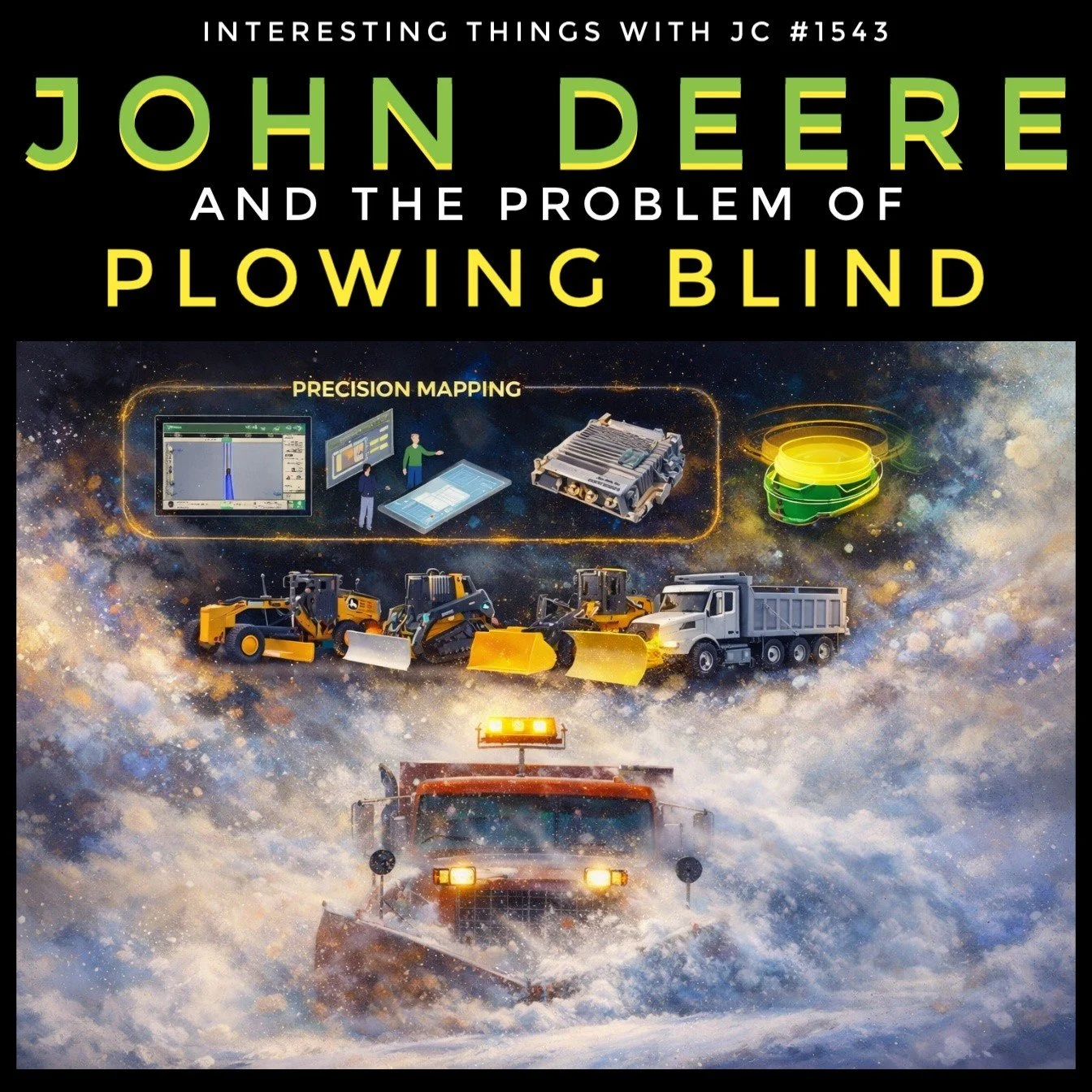
Podcast episode cover for "Interesting Things with JC #1543: John Deere and the Problem of Plowing Blind." The top section features bold text in green and yellow against a black background. Below, an illustrated scene shows snowplows moving through a fierce snowstorm with headlights on. Above the snowplows, a diagram labeled "Precision Mapping" includes digital displays, satellite receivers, control modules, and interface screens, representing the GPS guidance technology used in plowing. The image visually connects technology and heavy machinery in extreme winter conditions.
Transcript
Interesting Things with JC #1543: “John Deere and the Problem of Plowing Blind”
In Iowa, there are winter nights when the road doesn’t fade away slowly. It’s just gone.
February 2025 delivered one of those nights. Snow was blowing hard across U.S. Highway 30, pushed sideways by wind strong enough to stack drifts faster than plows could clear them. Visibility dropped to a few feet. Painted lines disappeared. Shoulders blended into ditches. Even familiar stretches of road turned into a flat white sheet.
That’s what snowplow operators call plowing blind.
Mohamed “Moe” Mohamed, working out of Iowa DOT’s District 1, had been through it before. When you can’t see the edge of the road or the centerline, the truck can drift without you realizing it. A few inches off, then suddenly you’re scraping a guardrail, clipping a mailbox, or dropping a wheel into a ditch. In storms like this, plows used to slow way down, stop often, or shut it down entirely. Roads stayed closed. Drivers got stuck. Ambulances waited. Crews burned fuel re-plowing the same stretches while other roads piled up.
This storm didn’t play out that way.
Moe’s orange plow truck was running John Deere Path™, a guidance system that didn’t start out in snow removal. It came from farm fields, where tractors have to run straight passes year after year, even in dust or darkness. In 2024, during joint research with Iowa DOT and Iowa State University on improving road safety in severe weather, the idea surfaced: if a machine can follow a path it can’t see in a field, maybe a plow can do the same thing on a highway.
They tested it during the 2024–2025 winter. It worked. By the following season, Iowa DOT expanded the program, adding equipped trucks—with subscriptions for ongoing support—across all six districts for the 2025–2026 winter.
The work starts long before the storm.
On clear days, when pavement is dry and visible, operators drive their regular routes. U.S. 30. Iowa 21. Iowa 8. A receiver mounted on the roof tracks the truck’s position using satellite corrections, accurate to about one inch, roughly 2.5 centimeters. As the truck moves, the system records where the road actually is—lane edges, shoulders, curves, and ditches. It also marks fixed trouble spots like mailboxes, curbs, bridge ends, and guardrails. That information gets saved digitally.
When the snow comes, that stored map shows up inside the cab.
A screen on the dash shows the truck’s position compared to the mapped road. It’s straightforward. A line to follow. A bar that shows if you’re drifting left or right. If the truck moves too far off course—often around six inches—an alarm sounds. Moe doesn’t have to see the road to stay on it.
The system doesn’t steer the truck. It doesn’t touch the wheel or the pedals. Moe is still doing the driving. The screen just gives him information his eyes can’t.
Even at plowing speeds of 25 to 35 miles per hour, about 40 to 56 kilometers per hour, the display keeps up. Routes can be shared between trucks so one driver’s map helps another. Supervisors can see which roads are open, how long routes take, and where crews are working.
That night on Highway 30, Moe kept moving when older methods would have forced him to stop. Heavy snow didn’t knock the signal out. Operators later noted that brief dropouts could happen under bridges or overpasses, but the system quickly recovered. Moe later said it never really lost signal in a way that stopped him.
The results showed up where it mattered.
Late in December 2025, during another whiteout, two plow trucks used the system to escort an ambulance 30 miles along U.S. Highway 18 from Garner to Mason City. The drivers couldn’t see the road, but the screen showed exactly where it was. The convoy stayed on pavement the entire way.
Across the state, routes using the system reopened about six hours sooner. Crashes dropped. Emergency vehicles got through faster. Crews spent less time guessing and less time redoing work.
What changed wasn’t the driver. It was the certainty.
This wasn’t about turning control over to a computer. It was about giving experienced operators a way to know where the road is when the storm takes their sight away.
When everything outside the windshield turns white, knowing where the road runs can make all the difference.
These are interesting things, with JC.
Student Worksheet
What is meant by the term "plowing blind"?
How does the John Deere Path™ system help drivers like Moe during a storm?
Why was satellite correction important to this guidance technology?
Describe how data is collected on clear days to assist during storms.
Imagine you're Moe during a whiteout. What would you rely on besides your eyes?
Teacher Guide
Estimated Time: 1 class period (60 minutes)
Pre-Teaching Vocabulary Strategy:
Use context clue activities and visual imagery (e.g., snowstorm simulation videos) to help students grasp technical terms like “guidance system” and “whiteout.”Anticipated Misconceptions:
Students may think the truck is self-driving. Clarify that the system assists but does not steer.Discussion Prompts:
How can agricultural technologies be adapted for public safety?
What are the dangers of poor visibility in other professions?
Is technology replacing or supporting human work in this case?
Differentiation Strategies:
ESL: Use labeled diagrams of the guidance system and GPS satellite.
IEP: Provide transcript with bolded key terms and simplified explanations.
Gifted: Investigate how precision agriculture works and compare it to this road use.
Extension Activities:
Students design a safety system for another profession using existing technologies.
Use GIS tools to map a snowplow route and simulate a storm navigation plan.
Cross-Curricular Connections:
Physics: Explore how wind and snow impact visibility and motion.
Geography: Map winter storm patterns in Iowa.
Digital Tech: Study how GPS systems maintain accuracy through corrections.
Quiz
What challenge does “plowing blind” describe?
A. A driver without training
B. Driving at night without headlights
C. Operating in whiteout conditions without visibility
D. Plowing without a GPS system
Answer: C
Where did the John Deere Path™ technology originate?
A. NASA research
B. Emergency rescue programs
C. Agricultural field guidance
D. Road maintenance software
Answer: C
How accurate is the system with satellite corrections?
A. About 1 foot
B. About 1 meter
C. About 2.5 centimeters
D. Exact to the millimeter
Answer: C
What happens if the truck drifts off the recorded path?
A. The system takes over steering
B. The system shuts down
C. An alarm notifies the driver
D. The screen turns off
Answer: C
What broader benefit was shown in December 2025?
A. More snow days for schools
B. Ambulances could travel during whiteouts
C. Roads required less salting
D. Drivers no longer needed to monitor routes
Answer: B
Assessment
In your own words, explain how John Deere Path™ helps improve safety during winter storms.
What other environments or industries might benefit from similar guidance systems?
3–2–1 Rubric
3 = Accurate, complete, thoughtful
2 = Partial or missing detail
1 = Inaccurate or vague
Standards Alignment
Common Core (CCSS)
CCSS.ELA-LITERACY.RST.11-12.3 — Follow complex multistep procedures (e.g., how operators map and follow routes using GPS).
CCSS.ELA-LITERACY.RI.9-10.1 — Cite textual evidence to support analysis (students cite from transcript).
CCSS.ELA-LITERACY.WHST.9-12.2 — Write explanatory texts to examine complex systems like precision navigation.
NGSS (Next Generation Science Standards)
HS-ETS1-1 — Analyze a major global challenge (navigating in extreme weather) and propose technological solutions.
HS-ETS1-3 — Evaluate a solution to a complex problem, understanding trade-offs (technology supporting vs. replacing operators).
ISTE Standards for Students
1.1 Empowered Learner — Use technology to set goals and understand systems in real-world conditions.
1.4 Innovative Designer — Identify and solve problems using new or existing technologies.
UK National Curriculum (KS4)
Geography — Understand how human and physical processes interact in storm events and infrastructure.
Design and Technology — Apply technical understanding to real-world problems (transport systems, weather adaptation).
Cambridge IGCSE
ICT 0417 — Understand GPS and real-world applications of data systems.
Geography 0460 — Study natural hazards and human responses (e.g., snowstorms and infrastructure resilience).
Show Notes
In this episode, JC dives into how an agricultural innovation—John Deere’s precision GPS guidance system, has been repurposed for life-saving snowplow work in Iowa. Facing dangerous whiteout conditions where visibility disappears completely, drivers like Moe Mohamed rely on a mapped digital line showing exactly where the road is—even when they can’t see it. With accuracy down to an inch and no automation taking over the wheel, this technology preserves human skill while extending its reach. This story is not only a fascinating example of cross-industry innovation but also an important lesson in adapting existing tools to solve new, high-stakes challenges. For students, it shows the power of applied science and engineering to keep infrastructure running and people safe, no matter the weather.
References
Iowa DOT. (2026). Iowa DOT’s visibility technology helps snowplow operators "see" roads during severe weather. https://iowadot.gov/transportation-matters/2026-01-13/iowa-dots-visibility-technology-helps-snowplow-operators-see-roads-during-severe-weather
John Deere. (2024). John Deere AutoPath Guidance Technology Overview. https://www.deere.com/en/technology-products/precision-ag-technology/guidance/autopath/
Iowa State University. (2025). DOT partnership on extreme weather navigation systems. https://www.intrans.iastate.edu/wp-content/uploads/2025/09/CARWIS_w_cvr.pdf