
1581: "The Central–Mid-Levels Escalator"
Interesting Things with JC #1581: "The Central–Mid-Levels Escalator" – In Hong Kong, the hill behind the harbor used to demand a daily climb. Then the city built a half-mile chain of moving steps that flips direction with the clock, and rewired an entire neighborhood around the flow of footsteps.
Curriculum - Episode Anchor
How Hong Kong solved a steep, crowded commute with a reversible, segmented escalator “chain”, and how that piece of infrastructure reshaped the neighborhood around it.
Episode Title: The Central–Mid-Levels Escalator
Episode Number: 1581
Host: JC
Audience: Grades 9–12, college intro, homeschool, lifelong learners
Subject Area: Urban geography, engineering design, human systems, transportation planning
Lesson Overview
Learning Objectives:
Define how topography (steep elevation change) constrains transportation design in dense cities.
Explain why a segmented escalator-and-walkway system can be safer and easier to maintain than a single continuous escalator.
Analyze how transportation infrastructure can influence land use and local business patterns (“activity clustering” along a route).
Compare two solutions to hillside mobility (roads/rail vs. pedestrian mechanized systems) using constraints described in the episode.
Key Vocabulary
Topography (tuh-POG-ruh-fee) — The shape of land surfaces; Hong Kong Island’s steep slopes make north–south travel challenging.
Gradient (GRAY-dee-uhnt) — The steepness of a slope; steeper gradients increase engineering and safety constraints.
Patronage (PAT-ruh-nij) — The number of users of a transit system; the escalator system’s daily use is measured in “pedestrian trips.”
Travelator (TRAV-uh-lay-ter) — A moving walkway (often inclined) that carries pedestrians without steps.
Induced demand (in-DOOST dih-MAND) — When adding capacity changes behavior so congestion may not fall as expected; officials have noted the system helps walking and transit demand more than it reduces car traffic.
Reversible operation (rih-VUR-suh-buhl op-uh-RAY-shuhn) — Infrastructure that changes direction by time of day; the system runs downhill in the early morning and uphill later.
Narrative Core
Open – Hong Kong’s land rises sharply behind the harbor; residents faced a daily uphill grind from Central to the Mid-Levels.
Info – Central became a highly concentrated business district, while the Mid-Levels housed many residents above it; the slope is steep and streets are narrow.
Details – Planners opened the Central–Mid-Levels Escalator system in October 1993: a connected chain of escalators and moving walkways that reverses direction by time of day and allows maintenance section-by-section.
Reflection – The route became a people-moving “spine” that encouraged shops and restaurants to cluster around entrances, reshaping street life and local commerce.
Closing – These are interesting things, with JC.
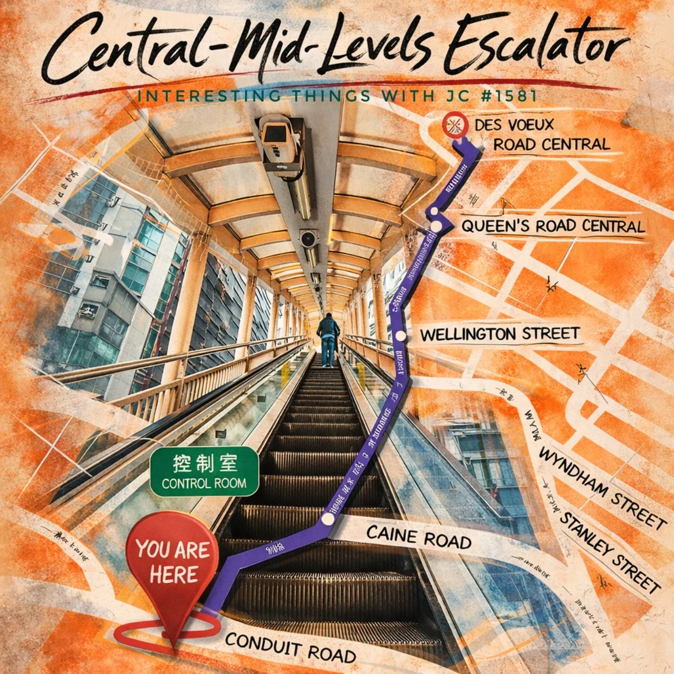
Central–Mid-Levels Escalator (Hong Kong): episode #1581 artwork showing the covered escalator corridor and a mapped route from Central up toward the Mid-Levels, with labeled streets and a “You are here” marker.
Transcript
Interesting Things with JC #1581: "The Central–Mid-Levels Escalator"
In Hong Kong, Heung Gong (HYUNG gong), the land rises quickly behind the harbor.
The Central district sits along Victoria Harbour, filled with office towers, banks, and trading firms. Just above it, the city climbs steeply into a residential area called the Mid-Levels. For decades, residents living there faced the same daily climb. Steep roads and long staircases just to reach the businesses below.
By the late twentieth century, Central had become one of the most concentrated financial districts on Earth. Tens of thousands of workers moved between the waterfront offices and hillside apartments every day.
But the hillside posed a problem. Streets were narrow. Buildings were tightly packed. The slope between Central and the Mid-Levels rises more than 443 feet (135 meters) over less than half a mile.
Building a road or rail system through those crowded streets would have required demolishing large sections of the neighborhood.
So city planners chose a different solution.
In October 1993, Hong Kong opened the Central–Mid-Levels Escalator system. The project cost about 240 million Hong Kong dollars, roughly 30 million U.S. dollars in early 1990s currency.
Instead of one continuous escalator, engineers built the system as a chain of twenty escalators and three moving walkways connected by elevated platforms. Together they stretch about 2,625 feet (800 meters), climbing roughly 443 feet (135 meters) up the hillside.
That segmented design solved several problems at once.
The steep gradient meant one long escalator would have been difficult to maintain and unsafe during breakdowns. By dividing the system into multiple sections, individual escalators can be stopped for maintenance while the rest of the route continues operating.
The segmented layout also allowed construction crews to thread the system through narrow streets and existing buildings without major demolition. Platforms connect to sidewalks at different levels along the hill, allowing riders to enter or exit at dozens of points.
Today the system moves roughly 85,000 passengers every day.
It even changes direction depending on the time of day. From about 6:00 a.m. until 10:00 a.m., the escalators run downhill so residents can reach offices and transit lines in Central. After that, the entire system reverses and runs uphill for the rest of the day.
A full ride from bottom to top takes about twenty minutes.
Over time, something else happened along the route.
Because thousands of people pass the platforms daily, restaurants, bakeries, markets, and small shops clustered around the entrances. Cafés and noodle shops filled the narrow streets connected to the escalator walkways.
A piece of transportation infrastructure reshaped the neighborhood around it.
Today the Central–Mid-Levels Escalator carries residents, workers, and visitors up a hillside that once required a long climb through steep streets.
In Hong Kong, Heung Gong (HYUNG gong), a half-mile chain of moving steps became part of the city’s daily life.
These are interesting things, with JC.
Student Worksheet
Why did steep terrain and dense buildings make roads or rail difficult to add between Central and the Mid-Levels?
List two reasons a segmented escalator system can be safer or easier to maintain than a single long escalator.
The system reverses direction during the day. What commuting pattern is it designed to match, and why?
Describe one way the escalator system changed the neighborhood economically or socially.
Creative prompt: Design a hillside mobility solution for a different city (real or imagined). What constraints (space, slope, weather, cost, safety) shape your design?
Teacher Guide
Estimated Time
45–60 minutes (single period)
Optional extension: +30 minutes design activity or short research share-out
Pre-Teaching Vocabulary Strategy
“Sketch-to-meaning”: Students draw quick icons for topography, gradient, travelator, patronage, reversible operation.
2-minute “turn-and-teach”: partners explain each term using a Hong Kong example from the episode.
Anticipated Misconceptions
“Escalators are just for malls” → clarify urban escalators as transit infrastructure in hilly cities.
“More infrastructure always reduces traffic” → introduce induced demand and different goals (walking access vs. car reduction).
“It’s one giant escalator” → it’s a network of multiple escalators and moving walkways, connected by platforms.
Discussion Prompts
What is the primary problem the escalator system solves: speed, safety, accessibility, land constraints, or something else? Defend your answer with details.
How might “where people walk” influence where businesses choose to open?
What tradeoffs come with reversing direction by time of day? Who benefits, and who might be inconvenienced?
Differentiation Strategies: ESL, IEP, Gifted
ESL: Provide sentence frames (“A key constraint was…”, “The system was designed to… because…”) and a labeled route diagram students create from the transcript.
IEP: Chunk tasks (cause → solution → result), allow oral responses, and offer a word bank for key vocabulary.
Gifted: Add a constraint—e.g., severe weather, higher peak loads, or limited maintenance windows—and ask students to redesign operations and justify choices.
Extension Activities
Mini research: Compare Hong Kong’s system to another hillside mobility system (e.g., funiculars, outdoor elevators, cable cars) and present pros/cons.
Data thinking: Students create a simple “demand curve” timeline (morning peak downhill, rest-of-day uphill) and propose alternative hours based on hypothetical schedules.
Cross-Curricular Connections
Physics/Engineering: friction, motor load on inclines, safety redundancy, maintenance planning.
Geography: human-environment interaction, land use, urban density constraints.
Economics: foot traffic externalities, commercial clustering, opportunity cost of demolition vs. retrofitting.
Quiz
Q1. What problem most directly motivated the Central–Mid-Levels Escalator system?
A. Lack of buses in Central
B. Steep terrain and dense streets making new roads/rail difficult
C. Frequent flooding along Victoria Harbour
D. A shortage of residential housing
Answer: B
Q2. Why is the system segmented into many escalators and walkways?
A. To make the ride slower for tourists
B. To allow sections to stop for maintenance while others keep operating
C. To avoid needing any electrical power
D. To increase car traffic uphill
Answer: B
Q3. When does the system generally run downhill?
A. Late night only
B. Midday only
C. Early morning commuter hours
D. It never runs downhill
Answer: C
Q4. About how long can a full bottom-to-top ride take?
A. 2 minutes
B. 8 minutes
C. About 20 minutes
D. About 60 minutes
Answer: C
Q5. What neighborhood change is described as happening along the route over time?
A. Farms replaced skyscrapers
B. Shops and restaurants clustered around entrances due to foot traffic
C. Central became a wilderness preserve
D. The harbor dried up
Answer: B
Assessment
Open-Ended Question 1
Explain how Hong Kong’s topography and density shaped the design choice (escalator network vs. road/rail). Use at least two constraints from the episode.
Open-Ended Question 2
Analyze one unintended (or secondary) impact of the escalator system on the surrounding neighborhood and explain why it occurred.
3–2–1 Rubric (for each question)
3 = Accurate, complete, thoughtful (uses multiple episode details; clear cause-and-effect reasoning)
2 = Partial or missing detail (some correct facts but limited explanation or only one supporting detail)
1 = Inaccurate or vague (misstates key facts or provides minimal reasoning)
Standards Alignment
NGSS HS-ETS1-2 — Design solutions to complex real-world problems by breaking them into smaller, manageable parts; matches the system’s segmented escalator/travelator design and maintenance logic.
NGSS HS-ETS1-3 — Evaluate solutions based on tradeoffs (cost, safety, constraints); aligns with comparing demolition-heavy road/rail options versus a threaded escalator system.
CCSS.ELA-LITERACY.RH.9-10.2 — Determine central ideas of a source; students identify problem → solution → impact from the transcript.
CCSS.ELA-LITERACY.RH.11-12.7 — Integrate and evaluate multiple sources of information; students compare the episode narrative with official descriptions of operations and usage.
C3 D2.Geo.4.9-12 — Analyze relationships between humans and environments; applies to how steep terrain drives unique transport choices and patterns of movement.
ISTE 4 (Innovative Designer) 4.a/4.c — Students define design problems, consider constraints, and iterate solutions through the extension “hillside mobility redesign” task.
UK National Curriculum (KS4 Geography: Human geography—urban processes) — Investigate how urban infrastructure influences land use and economic activity; fits the clustering of businesses along high-foot-traffic corridors.
IB DP Geography (Urban environments: sustainability and liveability, infrastructure and services) — Evaluate how transport systems affect accessibility and urban change using evidence-based reasoning.
Cambridge IGCSE Geography (0460) Topic: Urban settlements — Explain how land use patterns and urban functions respond to transport and site constraints (steep slopes, density).
Show Notes
Hong Kong Island’s steep hillside behind Victoria Harbour created a daily challenge: moving large numbers of people between the waterfront business core of Central and the residential Mid-Levels above it, where narrow streets and dense buildings limited options for building new roads or rail. The Central–Mid-Levels Escalator and Walkway System opened in October 1993 as a linked route of escalators and moving walkways that reverses direction to match commuting flows, downhill in the early morning and uphill afterward, turning pedestrian movement into reliable, everyday infrastructure. In classrooms, this story is a clear, concrete case study in how geography shapes engineering design, how designers manage constraints through modular systems, and how transportation can transform neighborhoods by concentrating foot traffic and encouraging local business growth.
References
Electrical and Mechanical Services Department, HKSAR Government. (2015). Life cycle of the world’s longest escalator link (conference paper). https://www.emsd.gov.hk/filemanager/conferencepaper/en/upload/61/cnfrnc-paper-20150705-09-3.pdf
Guinness World Records. (n.d.). Longest escalator system. https://www.guinnessworldrecords.com/world-records/69205-longest-escalators
Hong Kong Special Administrative Region Government. (2015, December 16). LCQ10: Hillside escalator links and elevator systems. https://www.info.gov.hk/gia/general/201512/16/P201512160340.htm
Hong Kong Transport Department. (2025, April 1). Hillside Escalator. https://www.td.gov.hk/en/transport_in_hong_kong/pedestrians/hillside_escalator/index.html
Hong Kong Tourism Board. (n.d.). Central—Mid-Levels Escalator. https://www.discoverhongkong.com/us/place-to-go/central-mid-levels-escalator.html